Theory and application of high precision positioning
Expected to finish reading in 12 minutes
From mobile Internet to Internet of things, location is a basic and indispensable information, but from the refined industry application requirements, only higher precision location information can bring higher value, people can more accurately know the location of things, know the specific location of people, and better manage enterprises, personnel or materials. For example, to ensure the personal safety of tunnel construction personnel, to assist the prison to build a global and visual supervision platform; to improve the safety assurance efficiency of the petrochemical industry; to help upgrade the intelligent management of the construction site.
However, the above industries have high requirements on ultra-high positioning accuracy, large capacity, low delay and high refresh rate.
Location and navigation technology is responsible for providing real-time motion information of carrier (such as autonomous vehicle), including carrier position, speed, attitude, acceleration, angular speed, etc. Autopilot often adopts the way of multi-sensor fusion positioning. This paper mainly introduces the application of IMU in automatic driving positioning.
Working principle of high precision positioning
At the perception level of unmanned vehicle, the importance of positioning is self-evident. Unmanned vehicle needs to know its exact position relative to the environment, and there can be no more than 10cm error in positioning here.
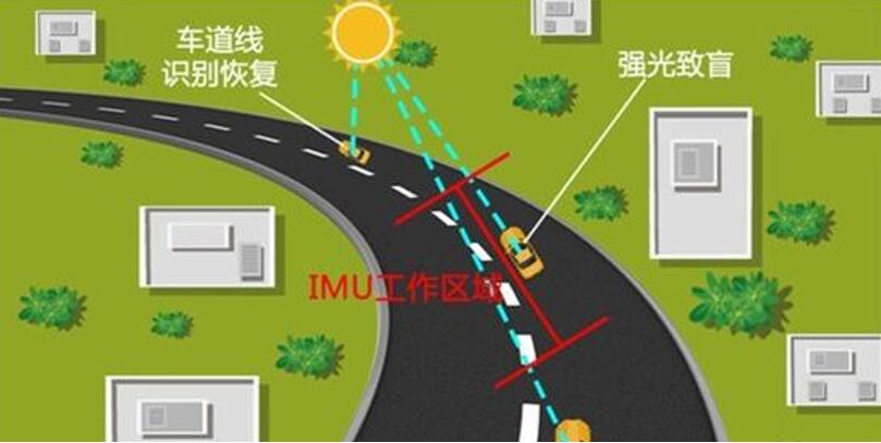
GPS can provide absolute positioning of meter level for vehicles, differential GPS or RTK GPS can provide absolute positioning of centimeter level for vehicles, but not all sections can get good GPS signals at all times. Therefore, in the field of automatic driving, the output of RTK GPS is generally integrated with the sensors of IMU and automobile (such as wheel speedometer, steering wheel angle sensor, etc.).
The full name of IMU is inertial measurement unit, which is usually composed of gyroscope, accelerator and algorithm processing unit. Through the measurement of acceleration and rotation angle, we can get the self motion track. We call the traditional IMU and the system combined with the vehicle body, GPS and other information fusion algorithms as the generalized IMU for automatic driving.
The emergence of this technology makes up for the lack of GPS positioning, and the two complement each other, enabling autopilot to get the most accurate location information. At present, the most widely used positioning method of unmanned vehicle is the integration of global positioning system (GPS) and inertial navigation system (INS).
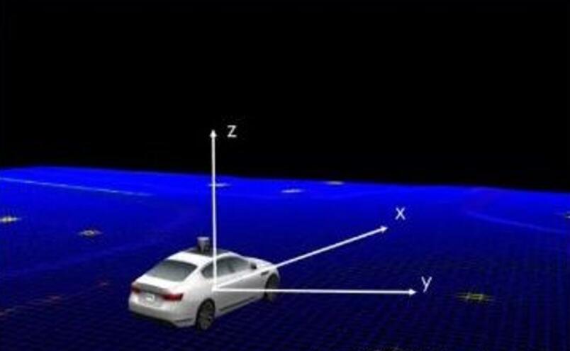
Integrated navigation involves complex coordinate system transformation, which requires initial calibration of the inertial navigation system. Generally, the reference navigation system (such as GNSS) is used to give the inertial navigation system an initial position value (the purpose is to establish the initial coordinate transformation matrix of the geographic coordinate system and the earth coordinate system) and initial velocity value; the initial attitude angle (the output of IMU) is obtained by the measurement value of IMU itself or by the measurement instrument (inclinometer or double skyline high-precision GPS orientation system) relative to the current The attitude angle of the horizontal navigation coordinate system, also known as Euler angle, initializes the quaternion and coordinate transformation matrix.
For the indoor positioning system, the customized local rectangular coordinate system (generally, a certain angle of the positioning area is selected as the origin, the boundary line as the x-axis, the right-hand criterion determines the y-axis, and the vertical ground upward as the Z-axis) is used as the navigation coordinate system. Because both are rectangular coordinate systems, but the origin and direction of the coordinate system are different, the origin displacement and axis rotation are required, so Initial alignment is also required. After the initial alignment, the ins calculation process is started, the quaternion and attitude transformation matrix are updated by reading the angular velocity measurement value of IMU, and then the velocity and position are updated. Finally, the velocity and position can be transformed to other target coordinate systems for expression, such as the longitude and latitude highland spherical coordinate system of GNSS.
High precision positioning method
In order to meet the requirements of autopilot for navigation and positioning, the following methods are adopted:
Inertial navigation ins
At present, the commonly used inertial measurement units (IMU) for automatic driving can be divided into two categories according to the accuracy: the first category is based on the fiber optic gyroscope (FOG) IMU, which is characterized by high accuracy, but also high cost, and is generally applied to map acquisition vehicles with high accuracy requirements. The second type is IMU based on MEMS devices, which is characterized by small volume, low cost, strong environmental adaptability, but the disadvantage is large error. If it is used in the automatic driving vehicle, it needs to go through more complex processing. In order to get the navigation and positioning output from the original data of IMU, the positioning system needs to solve sins, which includes the following four modules:
1. Get the attitude information by integrating the angular velocity information output by gyro
2. The specific force of accelerometer output is transformed by attitude information, and the navigation coordinate system is obtained from the carrier coordinate system
3. Carry out gravity calculation, harmful acceleration, earth rotation speed and other compensation calculation
4. Get the speed and position from the acceleration information integration
However, it should be noted that the output error caused by the integration process will accumulate with the working time
There are two ways for automatic driving to obtain wheel information: external and internal.
The characteristic of the external wheel sensor is that the resolution and precision are very high, the disadvantage is that the structure is complex, the reliability is difficult to guarantee, and it is generally more suitable for map acquisition vehicles. The characteristic of the built-in wheel sensor is that there is no need for external equipment. The disadvantage is that the accuracy is low and the error is large. If it is used for automatic driving vehicles, it needs to go through multiple processing. No matter which way is adopted, the wheel sensor is very important for the positioning system.
Motion constraints combined with vehicle motion characteristics
This kind of motion constraint can ensure that in extreme cases, the positioning results of the autonomous vehicle will not produce great errors.
Application in unmanned driving
There are different methods of automatic driving positioning, and the sensors involved are also different. Therefore, autopilot often adopts the way of multi-sensor fusion positioning. Multisensor fusion positioning generally includes the following parts:
·Data preprocessing: including inertial navigation solution, GNSS quality control, lidar data error compensation, calculation based on wheel sensor, online estimation and compensation.
·Matching and positioning based on lidar data and high-precision map.
·Four core modules:
1. ZUPT / zihr / NHC, vehicle motion restraint part
2. Ins alignment
3. Integrated, combined
4. FDI, fault detection and isolation
·Safety related modules: integrity monitoring of all outputs.
At present, the commonly used navigation and positioning optimization method is still based on the traditional Kalman filter, whose optimization index is to minimize the state variance. Generally, to build Kalman filter model, the first step is to select the state variables. At present, the state estimation is mostly based on navigation parameter error and vehicle sensor error. Then, through one-step prediction and measurement update, the state equation can be recursive in time domain. In addition, there are many traditional software methods for fault diagnosis and isolation of positioning system, such as chi square detection, etc., on the other hand, it can be realized by hardware redundancy. For example, with multiple GNSS / IMU, the positioning system can achieve multi-sensor redundancy with software analysis redundancy and improve reliability.
industry
According to different scenarios, mobile phone positioning, counting the number of moving watches and positioning the high accuracy of the automatic driving vehicle have different requirements for the accuracy of IMU, and the accuracy is high, which means the cost is high.
More accurate Imus will be used for missiles or space shuttles. In order to achieve higher accuracy of IMU, many manufacturers will add magnetometers on the basis of three accelerometers and three gyroscopes. In order to improve reliability, some will increase the number of sensors


 News
News
